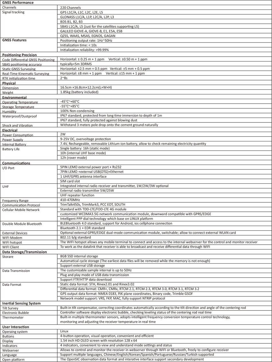

S86 GNSS Sensor
Adhering to the excellent quality and creating the high-end brand, the new S86 leads the new standard of the RTK measurement with multiple constellations and multibands receiving technology. Fusing strong practicability of the high precision integration, brings unparalleled efficiency measurement experience for the user.
Brand new Linux platform
Functional Web UI management
Double 50Hz update rate
CLOUD service
Excellent network modem
Smart PPP dialing
Built-in functional digital radio
Radio repeater: The rover can broadcast the corrections via internal radio
Advanced WIFI technology
Dual-mode Bluetooth V4.0
Intelligent temperature control technology
Intelligent storage
Visual HD display
Application in CORS system
Based on strengthening and perfecting radio stations, SouthGNSS closely follows the trend of the times and applies network RTK to various industries, taking the lead in the road of network RTK specialization. The South Continuous Reference Station system solution, independently developed and designed by SouthGNSS, provides a complete set of solutions from single base station to multiple base stations and multi-base station network systems. This scalable model allows different users to choose the best solution.
Marine application
SouthGNSS RTK and marine products are designed to meet the technical requirements of high-precision positioning and orientation at sea. They are also widely used in offshore engineering construction application.
Routine measurement applications
This product is also suitable for various control measurement, data acquisition and measurement and lofting, etc.
Electricity measurement
Using the power measurement function of South S86, it can conveniently carry out power line measurement orientation, ranging, angle calculation and other work, especially in some mountainous and hilly areas with poor visibility, which can more effectively play its convenient and efficient role.
Highway survey
Using the S86 system's fast static positioning and real-time dynamic positioning measurement modes and the measurement and highway lofting functions in the EGSTAR, it can cover highway survey, construction lofting, control point encryption, highway topographic map surveying, mid-pile surveying, cross-section surface measurement, vertical section ground line measurement and other applications of highway engineering.

This information is for reference only, in order to continuously improve product performance, all pictures and performance parameters on this website are subject to change without notice, please understand! The company reserves the final interpretation of all technical parameters and pictures.